Saturday, May 28, 2005

Doom

In the Land of Mordor where the Shadows lie.
One Ring to rule them all, One Ring to find them,
One Ring to bring them all and in the darkness bind them
In the Land of Mordor where the Shadows lie.

J.R.R. Tolkien – The Lord of the Rings Trilogy


The air is still and dark. Ice crystals crack under our feet as we climb into the land of shadows. Wisps of steam crawl along the blood-red earth, looking for ways of escape. In the distance, a mammoth peak rakes the darkened sky. Welcome to Mordor.

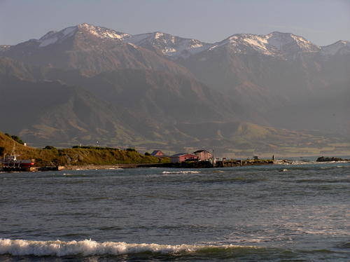
In recent times, the Lord of the Rings Trilogy has captured the world’s attention. Nowhere is this more apparent than New Zealand, home to director Peter Jackson and the myriad of locations where the three movies were filmed. In New Zealand, maps mark all filming locations, tour companies take people by mountain bike, bus, airplane, and helicopter to the sites, and LOTR books inundate the shelves.

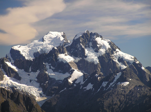
Of the many incredible sights seen in the movies, few are more impressive than Mount Doom, a dark, lava- spewing volcanic monolith, situated in the land of Mordor. It is Mount Doom where the greatest of the Rings of Power was forged, and it was Mount Doom where Frodo and Sam journeyed to destroy the Ring.


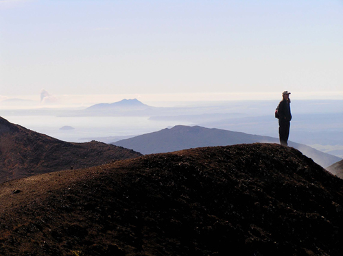
One of New Zealand’s Great Walks is the Tongariro Crossing, a one-day, 12-mile tramp through Tongariro National Park. This walk takes you through one of the most magnificent and desolate volcanic landscapes on the Pacific Rim, and leads you through three towering volcanoes, including Mount Ngauruhoe, otherwise known as Mount Doom. It offers spectacular views, amazing geologic sights, and with several thousand feet of climbing over the 8-hour hike, a wee bit of exercise.

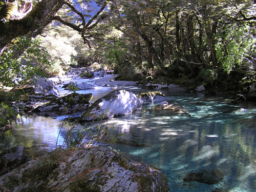
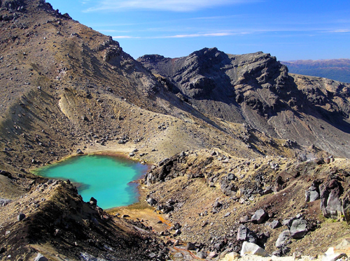
As an active volcanic area, the smell of sulfur permeates Tongariro National Park. Steam escapes from cracks in the trail, warming the hands of trampers on the way. Emerald green lakes dot the barren craters, and lava formations mark the twisted trail. Near the end of the track, a stream tumbles off the rugged flanks of the mountain, and down through the peaceful forest below.


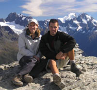
Trampers come by the busloads to experience the surreal landscape surrounding Mount Doom. Despite their crowded presence, the tramp does not dissapoint. The spectacular beauty of Tongariro gives credence to the claim that this is the best one-day walk in New Zealand.

Enjoy the Tongariro Crossing Photo Gallery.

Enjoy the Tongariro videos:
Mount Doom Steam Vent.
Emerald Lake Smoke.

Post a Comment

Tuesday, May 10, 2005

Art Deco City


In 1931, a huge earthquake hit the East Coast of the North Island of New Zealand, killing hundreds of people, and destroying every building in sight. The town of Napier, and its sister city Hastings, sat directly in the crosshairs of the disaster. Both towns were, quite literally, flattened.

Napier found itself 40 sq kilometers larger after the quake, as a result of the immense upheaval of the sea floor above sea level. A deadly series of fires ripped through the town, and there was nothing that could stop the flames. When everything was over, there was nothing left.

This was during the Great Depression. Although that sounds like adding insult to injury, it was actually a boon for Napier. The high unemployment meant there were plenty of folks interested in working on the rebuilding effort. As a result, the city was completely rebuilt from scratch within two years. This rebuilding took place during the height of Art Deco style. Everything was pointed towards the future. Automation, speed, and modernity were in. Victorian sensibility was out. Because of this unique construction boon, Napier became one of the Art Deco capitals of the world.

Thanks to a dedicated sense of preservation, Napier retains its Art Deco charm today. People stroll down streets that look right out of the 1930s. The beautiful black sand beach is fronted with a wonderful public garden, and an art deco clamshell amphitheater. The historic buildings look like new, and Napier has become famous for its unique sense of style.


Enjoy the Napier Photo Gallery.

Post a Comment

Monday, May 09, 2005

Wellington, I Presume

New Zealand’s capital city is an eclectic mix of cafes, galleries, and shops. The city drapes itself languidly across lush green hills, and drips down towards a vibrant waterfront. Although universities infuse a measure of youthful energy, the red cable cars climbing the steep slopes of Wellington retain a spot of old-world charm. A dose of Maori culture gives a unique and wonderful diversity to it all.


The spectacular Te Papa National Museum adds an educational and artistic bent, while the bustling harbor reminds you that this is a working town. The wonderful public gardens provide a softer side, while the busy ferry terminal brings a continuous stream of visitors to add a bit of excitement. Old European style architecture mixes with modern Kiwi, to create a look all its own.


Wellington is hip, happening, energetic, and cool. It’s the perfect jumping off point to see the wonders of the North Island.

Enjoy the Wellington Photo Gallery.

Enjoy the Video of Wild Parrots outside of Wellington.

Post a Comment

Marlborough

Marlborough is not about cigarettes, nor is it a street in Boston’s Back Bay. No, Marlborough is a postcard-perfect region of the spectacular South Island of New Zealand. Marlborough is about sunshine, vineyards, whale watching, rugged beaches, and snow capped mountains. It is a visitor’s dream.

Seals play in the pounding surf, sleep on the rocks, and bark at onlookers. Whales glide through the offshore waters, occasionally breaching in front of the huge mountain backdrop. Penguins fly through their undersea world, and nest on deserted beaches. Sheep graze languidly atop the verdant green hills, watching it all unfold before their eyes.


We used Marlborough as a jumping off point for the North Island. Lynn’s parents, Joyce and Shel, flew in to Christchurch to join us for the last few weeks of the World Tour. After granting them a couple days to beat jet lag, we drove north towards Marlborough, intent on discovering the perfect end to our South Island Tour. We were not disappointed.

From Christchurch, vineyards stretch north to Marlborough Sound, filling broad valleys and flanking deep green hillsides. Quaint towns dot the landscape, making it the perfect place to while away some time. Kaikoura sits spectacularly at the northern end of the Southern Alps. Sandwiched between soaring peaks and incredibly rich ocean waters, this old fishing town has been given new life by visitors intent on seeing its vivid natural beauty.


At the northern end of the Island sits majestic Marlborough Sound, the placid gateway to the North Island. Ferries chug in and out of Picton, carrying passengers to and from the cosmopolitan capital of Wellington. Lush forests line the quiet waterways and boats bob in the calm water, while seals sleep in the grass soaking up the New Zealand sun.


Our four weeks on the South Island has been incredible. We have driven nearly 4,000 kilometers (on the left side of the road, no less), and have seen more natural beauty than we could have imagined. Immense mountain peaks, crystal clear trout streams, pristine beaches, funky towns, lush vineyards, and rugged coastline – the South Island has it all. The trip is almost over, but there is still some fun to be had. Stay tuned for our adventures on the North Island.

Enjoy the Marlborough Photo Gallery.

Enjoy the Marlborough Seal Videos:
Thundering Waves.
Pups Playing with Dad.

Post a Comment

Thursday, May 05, 2005

Abel Bodied


Waves lap around our ankles, fish frolic in the crystal clear water, seals lounge on off shore islands, and exotic birds fill the skies overhead. Earlier today we pushed off from Marahau in a sturdy sea kayak to ply the glassy ocean waters. Already we have seen a Manta Ray gliding beneath our paddles. Now, a Pied Cormorant pokes around a deserted beach looking for dinner. The rocks are slathered in green-lipped mussels, with on occasional starfish mixed in for a little color.


Our campsite sits on a deserted fern-fringed beach. Rugged rainforested hills rise up behind us. We watch the cormorants swim through the tubes of incoming waves, like ancient Hawaiian surfers in search of their rush. Young seals watch from the jagged rocks, and fly underneath our kayak, their curiosity pulling them seaward. As they play and roll in the deep blue, their parents bark instructions not to go too far.


The water is deserted, save the occasional boat. Suddenly a pod of bottlenose dolphins roars past, taking flight just for fun. We sit in awe of the wonders of nature. This is the magic of Abel Tasman National Park.

Enjoy the Abel Tasman National Park Photo Gallery.

Enjoy the video of a young seal playing in Abel Tasman National Park.

Post a Comment

Tuesday, May 03, 2005

I Wanna

Mist hangs heavy over the rainforest. Somewhere above, towering peaks leap from the low-grade clouds into the brilliant blue. The valley is filled with the cacophony of falling water, and every so often the steely ice groans as though its arthritic knees are giving way. There are two places on the planet where glacial fingers of ice reach deep into lush rainforest. Guess what? New Zealand is one of those places.


We came to Fox and Franz Joseph Glaciers with the hope of walking on the ancient blue ice. Wanting to feel the life contained in the frozen rivers, we were ready to part with the funds required to hire a guide and the proper gear. However, we were waylaid by Wanaka. Wanaka, New Zealand, that is.

I wanna live in Wanaka. Huge mountains shelter the quaint town on the shores of a picture-perfect lake. Gin-clear streams meander through the valley, and ten-pound trout call them home. Waterfalls thunder from above. Ski fields dot the local peaks. Trails snake into the surrounding wilderness, and Mount Aspiring National Park provides a stunning backdrop to it all.


We had planned to stop for one night, but were beguiled by Wanaka’s charms, and couldn’t tear ourselves away for two days. Oooops, no ice exploration this time. Big rainbows will have to suffice.

From Wanaka north, one sees icy-cold glaciers and perfect white sand beaches within moments of each other. Unexplained geologic formations dot the coast, and seals and penguins frolic in the Tasman Sea. There are few people, and the folks that are there are warm and welcoming. It is far from the stress and aggravation of modern life. It is the kind of place you could stay forever.


Enjoy the West Coast Photo Gallery.

Enjoy video of New Zealand's crazy flightless Weka.

Post a Comment

Sunday, May 01, 2005

The Great Walk

Tramping in New Zealand is a religious experience. Home to some of the world’s best walks, thousands of people pilgrimage to New Zealand every year to walk among Nature’s gifts.


We chose to walk the Routeburn Track, a three-day, 33-kilometer feast for the eyes. Starting in Mount Aspiring National Park, the track traverses through New Zealand’s most stunning wilderness, past crystal clear trout streams, dazzling alpine meadows, impenetrable rainforest, and bottomless mountain lakes, ending in Fjordland National Park near Milford Sound.

We start the walk near Glenorchy, New Zealand, famous for its Lord of The Rings vistas. The track starts on the bank of the Routeburn River, where trout can be spotted in the gin-clear depths even from the trail hundreds of feet away. After catching a few of these New Zealand beauties on a flyrod, we follow the track west through a rainforest carpeted in silver ferns. The river and trail play tag, with rustic swing bridges periodically spanning the chasm. Before long we find ourselves in the picture-perfect Routeburn Valley, with only a steep climb and a handful of waterfalls separating us from the Routeburn Falls hut - our destination for the evening.


Day two starts with a glorious sunrise ricocheting off the waterfalls and tarns of the high alpine. Hiking up to the Harris Saddle, we are treated with mind-blowing vistas, thundering water, and even a rare alpine skink. Cresting the saddle our jaws drop, as the grandeur of the Hollyford Valley reveals itself. Jagged glacier-clad peaks thrust to the heavens, while in the distance waves pound a secluded ocean beach. It is a dichotomy unlike any we have ever seen.

We finally tear ourselves away, and hike along an exposed ridge, constantly buffeted by some of the best views in the world. A myriad of crystal-clear streams fall down the steep slopes beneath our feet, while far below, the trout-choked Hollyford River tumbles north to the sea. Eventually, we drop through a mystical rainforest to picturesque Lake McKenzie to the McKenzie Hut.


We wake on day three to a light drizzle, and set out towards Lake Howden. The fog and mist gives a surreal light to the intense New Zealand fauna. Moss and lichen literally drip from the trees, and every turn reveals a new waterfall plunging down the step green slopes. Soon, the sun burns away the gray, revealing rugged snow-clad peaks above the forest canopy. As we drop down towards Fjordland, sunlight streams through the trees, illuminating the moss-draped trunks with an ethereal green glow. We smile as we reach the end, knowing we have just completed one of the greatest walks in the world.

Enjoy the Routeburn Photo Gallery.

Enjoy the Routeburn videos:
Conical Hill Panorama.
Falling Water.

PostScript – Although the Routeburn Track is only 33 kilometers, a drive from the trailhead in Glenorchy to the end point near Milford is more than 350 kilometers. Southwest New Zealand is real wilderness, and roads are rare. It is truly nature at its unspoiled best. That explains why National Geographic just listed it as one of the 10 best hikes in the world.

Post a Comment